 MENU
MENU
Cape Town Hiking and Climbing
A rough guide to hiking, scrambling and climbing routes on the Cape Town Peninsular.
Also listed are routes east of Cape Town including Helderberg, Gordon’s Bay and Stellenbosch. There is easy access to the main Cape Town mountains from the coast. The Wolfberg Crack and climbing routes in the Cederberg mountain range are 200 km north of Cape Town.
Cape Town Facts
Cape Town is a photogenic city with a Mediterranean type climate similar to the Spanish Costa Blanca. A significant difference is that the mid winter is in July and mid summer is in January.
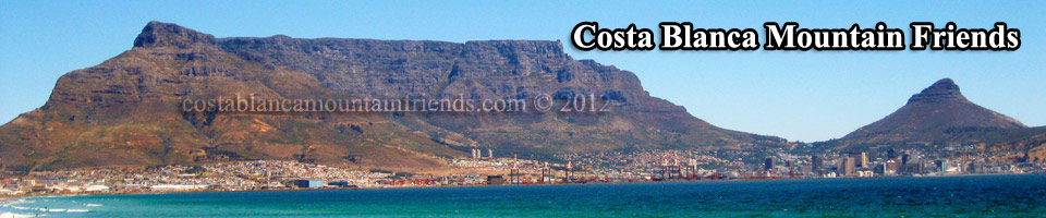
The whole of Cape Town and surrounding areas and coastline are dominated by the spectacular outline of Table Mountain with a height of 1084 metres. Rich in history and diverse in culture South Africa won the prestigious 2010 FIFA award making it the first African nation to host the World Cup. Cape Town with its new outstanding Green Point stadium became one of the host cities. Flight time from London direct to Cape Town is 12 hours.
Mountaineering in Cape Town and other areas
Deaths and injuries occur on Table Mountain mainly through falls while scrambling on unfamiliar and dangerous routes. Also, many people wander around the various hiking routes for hours with no map or guide book or without adequate nourishment or water.
If you are going to hike or scramble then get yourself a map and a scrambling guide from most bookshops or Cape Union Mart.
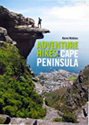 There are two essential guides to hiking and scrambling routes on the Cape Peninsular written by Karen Watkins. Search on Google for Adventure Walks and Scrambles in the Cape Peninsula and Adventure Hikes in the Cape Peninsula. Available from various bookshops in Cape Town.
 Useful mountain maps and guides covering Cape Town and areas beyond can be obtained from Slingsby Maps.
Table Mountain Treks and Tours
Visit many sights of the city and its mountains. Ranging from personalised private tours to informative hiking trails.
Hiking, Scrambling and Climbing Routes
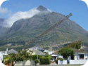
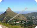 Lion’s Head. Height 669 metres. An easy grade 1 scramble and hike takes you to the summit with spectacular views of Table Mountain, Signal Hill, Clifton Bay and Camps bay. This is a typical tourist route and can be accessed by parking near Kloof Nek or at the small parking area on the Signal Hill road. Allow 50 minutes for the ascent.
 Plattenklip Gorge. Most tourists who want to ascend Table Mountain by foot use this direct route. The ascent is steep and leads to the summit and upper cable car station. There is no scrambling involved and the track is well constructed with rock steps. Access is from Kloof Nek. Follow the Tafelberg road and continue passed the lower cable car station for 1.5 km. Limited parking is available near a bend in the road. Allow 1 hour or more for the ascent.
 Devil’s Peak. Height 986 metres. A classic Table Mountain hike and grade 2 scramble. Once passed the Blockhouse there is a long ascent to Knife Edge which leads to the 865m Minor Peak. Crossing the Knife Edge ridge involves a scramble normally in high winds. From Minor Peak follow the track that leads to Devil’s Peak. Descent can be via Newlands Ravine and then on the Contour Road. A good starting point is the Rhodes Memorial car park. Allow 5.5 hours for the total route. Distance 8.5km. Ascent 1540m
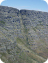
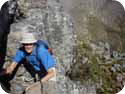
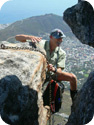
 Spring Buttress. A classic Table Mountain scramble route. The author Karen Watkins is seen featured in our photo. Start point is near Wood Ravine just off the Pipe Line.
The scramble involves grade 2 pitches through boulders with plenty of exposure. As with most Table Mountain routes the views are spectacular. On a hot day descent can be via the cable car. Allow 4 hours for the ascent alone.
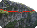 Carrell’s Ledge. Located just east of Maclear’s Beacon this notorious ledge varies in width from a few metres to just 20 cm in one particular place. There is one scramble around a boulder and then the track gradually narrows with a sheer drop of several hundred metres and with several holes and roots underfoot. For climbers this route is not a challenge but for hikers it could be quite exciting. Not recommended in wet conditions. Allow 45 minutes for the full traverse. See our YouTube video
 Indian Fenster. A classic grade 2 Table Mountain scrambling route. The route can be started from Kloof Nek or the lower cable car station. Allow 3 to 4 hours for the ascent. See our YouTube video
 Kloof Corner. Another classic grade 2 scramble on Table Mountain. Can be started from Kloof Nek or the lower cable car station. The initial route is the same as Indian Fenster but then veers off in a different direction. The scramble culminates with a tricky climb through a 30 cm crack between a large block and the rock face using a chain. Once on the exposed rock shelf the views of Cape Town and Lion’s Head are spectacular. From here the route continues to the cable car. Allow 3 hours or more for the ascent. Return via the cable car on hot day.
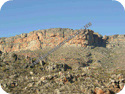
 Hottentots Holland Ridge. Height 555 metres.
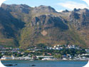
Overlooking Gordon’s Bay Harbour this imposing ridge can be climbed and then traversed to Sir Lowry’s Pass.
Park near Suikerbossie Drive. 34° 09’ 58.91” S 18° 51’ 39.82” E
The short but steep ascent leads to the prominent GB sign set in the mountain side. From there further scrambling will reach the main summit and the upper Steenbras Dam track. Follow this track to the Sir Lowry’s Pass viewpoint and return by Taxi.
Parking long term at the Sir Lowry’s Pass view point is not recommended.
Allow 4 hours from Gordon’s Bay to the view point. Distance 9km. Duration 3hrs. Ascent 770m.
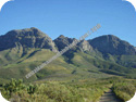 Helderberg. Dome Height 1137 metres. Located at Somerset West the Helderberg is a prominent mountain with a number of peaks. Easy access is via the Helderberg Nature Reserve secure car park. A map is available from the information centre showing the route to Disa Gorge. From the gorge there is an easy track to the main west peak. The Dome is one hour further on. Return can be via another route. West Peak Distance 10km. Duration 4hrs. Ascent 870m. The Dome distance 13km. Duration 6.45 hrs. Ascent 1169m. Car Park. 34° 03’ 44.6” S 018° 52’ 24.1” E
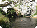 Crystal Pools. A well known beauty spot accessed from the Steenbras River Trail. From Gordon’s Bay take the R44 along Faure Marine Drive towards Kogel Bay. Just around the headland about 4 km from Gordon’s Bay you will reach the Steenbras River Bridge. Permits for accessing the trail can be obtained from the Sunbird Guest House located 100 metres just before the bridge on the right hand side. Park 34° 11’ 46.7” S 18° 49’ 20.36” E. The permit cost was R15 in February 2011.
Opening hours 0730 to 1500. Secure parking is available at the guest house or public parking just over the bridge. The trail starts from the control box at the end of the bridge. Allow 45 minutes to reach the pools.
 Wolfberg. Height 1609 metres. Located 200 km north of Cape Town near the Sanddrif Campsite in the Cederberg Mountains. Stunning views of rock and cave formations in the Wolfberg Cracks.
Numerous trad climbing routes ranging from 17/5c to 22/6b+
All heights, distances, times, grades and equipment and other information listed on this page are provided in good faith as experienced by the author but may include errors. Anyone attempting these routes should verify the information before commencing the activity in case of errors, route modifications or geological changes.
1. A hike is a long walk. 2. Ascent figures are accumulative starting from the car park. 3. Duration of the event includes short stops, a short lunch break and brisk pace. 4. Distance and ascent figures have been derived by GPS. 5. Position coordinates are in decimal degrees.